Description
Product details
Product information
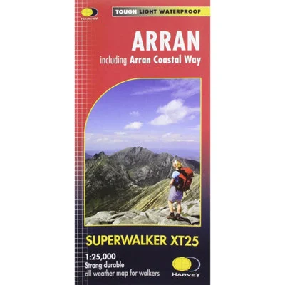
A fully detailed, exceptionally clear map for walkers and outdoor explorers covering the entire Isle of Arran at the popular 1:25,000 scale (4cm = 1km). It features the island’s renowned peaks and routes, including Goat Fell, A’Chir ridge, Beinn Bharrain, Glen Sannox, and Glen Rosa. The full 100km (62 miles) of the Arran Coastal Way is clearly shown, linking the island’s rugged coastline with its villages and spectacular inland scenery. This map also includes a Gaelic–English glossary and highlights archaeological and historical points of interest. Pubs and cafés are marked to help plan refreshment stops along your route. GPS compatible and less than half the weight of a laminated map, it’s made from HARVEY’s Superwalker XT paper—strong, tough, and 100% waterproof. Designed to be used without a map case, it opens directly to either side and folds easily for convenience. Covers all 4 Corbetts and the island’s single Graham.
- Guarantee – Statutory
Features and benefits
- Covers entire Isle of Arran
- Includes Arran Coastal Way (100km)
- GPS compatible & easy to read
- Dimensions: Flat size: 1392 x 486mm / Folded size: 116 x 243mm
- Scale: 1:25,000 (4cm = 1km)
- Waterproof, tough & lightweight (60g)
Reviews
There are no reviews yet.