Description
Product details
Product information
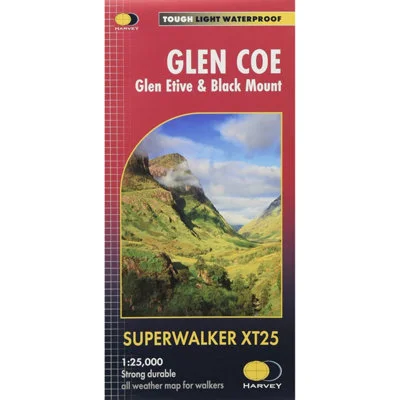
A detailed and exceptionally clear map for hillwalkers covering the dramatic landscapes of Glen Coe, Glen Etive, and the Black Mount at the popular 1:25,000 scale (4cm = 1km). This map includes iconic features such as Buachaille Etive Mòr, the Three Sisters of Glen Coe, Bidean nam Bian, and the exposed Aonach Eagach ridge. Coverage now extends east of the A82 to include Beinn Achaladair, Beinn an Dòthaidh, and the Bridge of Orchy area. Ideal for Munro bagging, it features 24 Munros and 10 Corbetts, with Rights of Way clearly marked to support route planning. It is GPS compatible, fully detailed, and shows tracks, ridges, and paths with outstanding clarity. Tough, durable, and 100% waterproof, it is printed on HARVEY’s Superwalker XT material. This map folds easily, opens directly to either side of the sheet, and is designed for use without a map case. At only 60g, it’s less than half the weight of a laminated map, making it perfect for mountain adventures.
- Guarantee – Statutory
Features and benefits
- Covers Glen Coe, Glen Etive & Black Mount
- GPS compatible & exceptionally clear
- Waterproof, durable & lightweight (60g)
- Scale: 1:25,000 (4cm = 1km) & Area covered: 668 sq km
- Dimensions: Flat size: 1392 x 486mm / Folded size: 116 x 243mm
Reviews
There are no reviews yet.